Colorado is an outdoor junkie paradise for those who like to lace up the old shoes, throw a pack over their shoulders and head to the trails for a day of adventure. In fact, there are more than 5,600 miles of trails all over the state, some more popular than others. But if you’re looking for something different this spring and summer, maybe some trails that don’t get too much attention or just offer some good times outdoors, then these are just for you.
Saint Mary’s Glacier Trail
Length: 1.5 miles (roundtrip) – Closest town: Idaho Springs – *Special Note: $5 parking fee

Have you ever sledded down a glacier in the summertime? If not, St. Mary’s Glacier, one of 14 glaciers in the state, is the perfect opportunity to knock a great experience off of your bucket list.
The hike: The quick 3/4 mile hike starts about 100 yards from a rock-strewn parking lot just off County Road 275 outside of Idaho Springs and climbs steadily on a wide, rocky forest road lined by bristlecone pine trees and private property markers. Early in the season, there are patches of muddy snow and slippery spots along various points on the trail, but dodging fellow hikers can be more of an obstacle on busy weekends. What the hike lacks in overall distance it makes up for it when the forest breaks and the trail leads to a gorgeous view of Saint Mary’s Lake reflecting a mosaic of blue skies and snow-capped ridgelines. From the lake shore, you’re free to watch skiers shoot down the slopes, enjoy lunch, or continue north with sled in hand up the glacier for a little extra fun.
Paradise Cove
Length: 1 mile (roundtrip) – Closest town: Florissant

Tucked away just off little known County Road 112 south of the quiet mountain town of Florissant, is a small yet unique and beautiful swimming hole with a whole lot of fun if you like cliff diving into frigid mountain water.
The hike: A trail starts near the small parking lot that can fill up by late morning so get there early. From there the trail descends down a few small outcroppings to a gate and then finally into a narrow granite-lined valley with two easy creek crossings for a majority of the .4 mile hike. It’s an easy walk along the creek before ascending into the trees and finally finding the sign warning of the impending danger of the area. Walking along the outcropping of rocks will offer an overall view of the cove while a short yet steep walk further down the trail will get you right to the water’s edge.
Paradise Cove is a picturesque swimming hole surrounded by walls of granite and fed by a tiny waterfall. Even with the number of people who can be there on any given weekend, it’s still a laid back place perfect for all ages, not to mention an outdoor heaven for backflipping adrenaline junkies like Noah and Brandon who I met after a few jumps of their own.
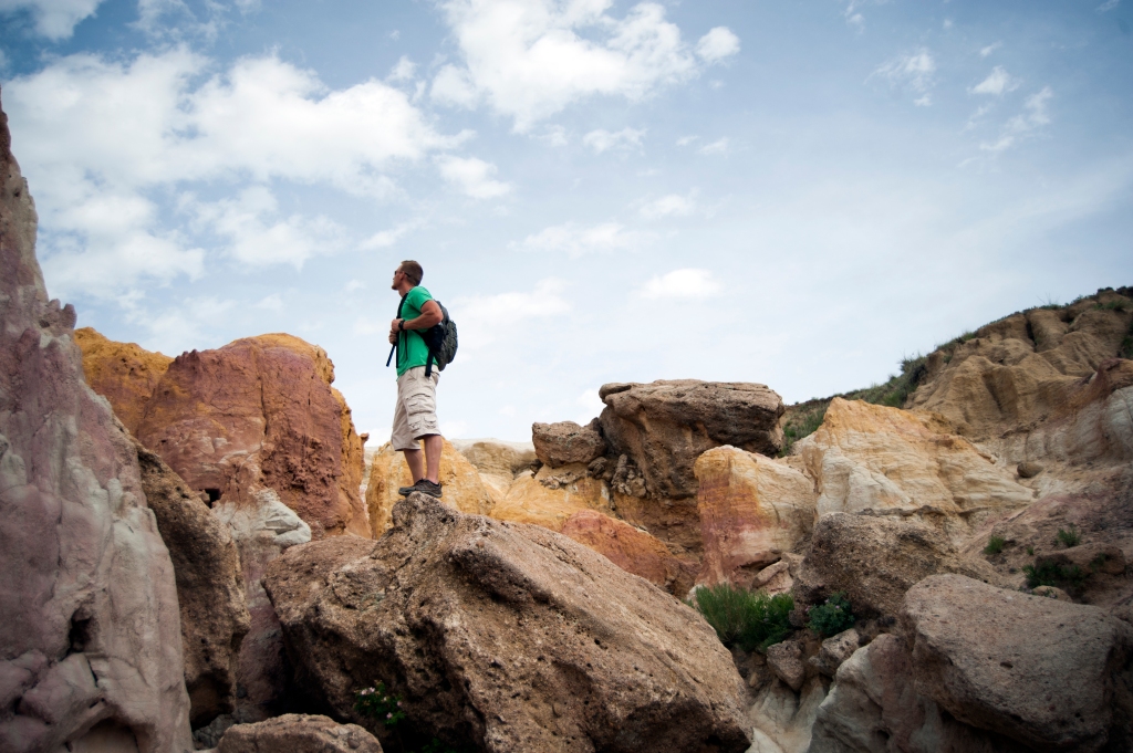
Paint Mines Interpretive Park
Length: 3.6 miles (roundtrip) – Closest town: Calhan

Fifty-five million years ago, this place was a tropical hardwood forest. Now Paint Mines is a unique, wind and rain battered landscape outside of a little town called Calhan.
The hike: Out here in the alien landscape of badlands, gullies, and colorful hoodoos, there are no whistling pine trees, mountain vistas, rushing water, or heavy weekend traffic. From the very start of this hike, it’s all about expansive views, a howling prairie wind, and near solitude as the trail leads up a small ridge where the geologic formations of Paint Mines finally come into view. The entire figure-eight loop offers a journey through time by leading both around and right into the heart of white clay formations and deep red-orange hoodoos; much smaller cousins of what you’d see in Bryce Canyon, yet still impressive.
Picketwire Canyonlands
Length: 10.6 (roundtrip to dinosaur tracks) – Closest town: La Junta


Each step along this trail sends you deeper and deeper into the history of Comanche National Grasslands ranging from Mexican pioneers and prehistoric Native American, migrating hunter-gatherers to the footprint remains giants plodding along a shallow lake 150 million years ago.
The hike: The round trip length of this hike depends on how far you want to go but begins all the same with an early 250-foot descent into the canyon. The initial part of the hike will take you through high native grass and past prickly pear and cholla cactus that all take on a beautiful morning color if you get an early start like I did. If the Delores Mission and Cemetery (built between 1871 and 1889 by Mexican pioneers settling the valley) is your destination, prepare for a 6.4-mile roundtrip hike through an ever-widening valley full of wildlife and gorgeous views. For dinosaur enthusiasts, the trip to the largest track site in the world (over 1,300 of these footprints extending on a 1/4 mile plain) means you pass the mission and cemetery, continue along the trail for another 1.6 miles, and then finally ford the river before you can walk alongside the footprints of Brontosaur dinosaurs. The total hike to the tracks and back to the trailhead is 10.6-miles so get an early start, bring plenty of water and sunscreen, and prepare yourself for an amazing experience through history.
*Special Note: After the hike, make sure you head to Lucy’s Tacos on 3rd Street for the best Tex-Mex food in La Junta. Eat the tacos, the enchiladas, the tostadas, and the amazing carne asada fries. I did.


Leave a comment